A Queer Map is written by Kevin Allen, illustrated by Mark Clintberg.
The forgotten Calgary, now mapped
Instead of your phone, try this.
When you think of Calgary’s history, what first comes to mind?
For me, it’s an image of Fort Calgary: the replica white barracks with its distinctive red trim, standing near the confluence of the Bow and Elbow rivers.
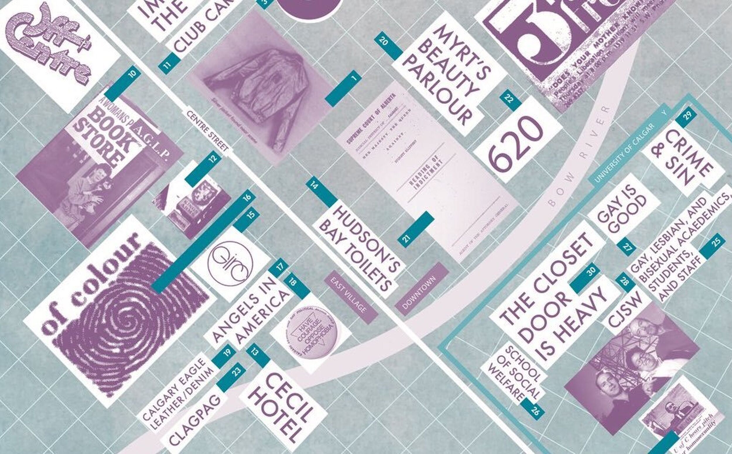
A new mapping project aims to expand the answers to that question by illuminating alternative narratives of the city. A Queer Map: A Guide to the LGBTQ+ History of Calgary reveals a lesser-known side of Calgary, from the plaza where a rally kicked off the city’s first pride parade in 1991, to a gay club dating back to 1939 in a walk-up Beltline apartment building.
This charming map, featuring 30 stories of LGBTQ+ history, is the first for The Calgary Atlas Project. The project is an initiative of the U of C’s Calgary Institute of the Humanities (CIH), which aims to produce about 20 different maps.
In Calgary, a relatively young city where “demolition by neglect” is a practised path for our heritage buildings, we openly lament the loss of our built history—as we should.
But it’s harder to notice the other histories we’re losing or have lost, a fact The Calgary Atlas Project addresses.
A lot of that history gets lost very quickly, because it’s not part of the official history.
“It gives a kind of permanence and recognition to that particular history,” said Jim Ellis, the project’s lead.
Ellis is director of the University of Calgary’s CIH and a professor in the department of English. “This is not the history of things that people generally aim to preserve. So to be able to have something concrete like this, to literally hold on to, is good.”
I think good is an understatement. I picked up a copy of the map from Ellis’s U of C office, and started by reading about seven spots and stories on campus. Unknown layers of a campus I’ve been on countless times quickly emerged.
The project’s work, of bringing to life overlooked or unknown backgrounds through words and art, is crucial. Ellis says it’s astonishing how rapidly queer history has changed in Calgary.
“A lot of that history gets lost very quickly, because it’s not part of the official history,” he said.
“We’re remembering that these sites did exist and still do exist in some way, in the memories of some people. These histories formed the current city.”
“We're thinking about how every present city is haunted by its ghosts; the ghosts that formed it in some way. To bring those kinds of histories to life is, I think, a positive act of memorialization.”
Check out a new queer history map of Calgary illustrated by Mark Clintberg. Its typography draws on the signage of Calgary's former Cecil Hotel, where lesbians met for many years. Learn more: https://t.co/O0wMg5EstM What are the legendary #LGBTQ+ institutions in your town? pic.twitter.com/lTFAl6CXxP
— teganandsarafdn (@teganandsarafdn) December 17, 2019
Future maps will delve into other little-known parts of Calgary’s past, including the history of First Nations and the Calgary Stampede; lasting effects of the labour movement; sites of old movie palaces and spots featured in films; immigrant movements as illustrated by the coming and going of restaurants; and a chronicle of alternative art movements and galleries.
For each map, Ellis approaches a historian and artist connected to the map’s topic. The text in A Queer Map is by Kevin Allen, author of Our Past Matters: Stories of Gay Calgary, and the art is by Mark Clintberg, an artist and assistant professor at the Alberta University of the Arts.
For the next map — expected to be printed in the spring — the focus is on the history of First Nations and the Calgary Stampede.
As I was working on it, it dawned on me that maps themselves are this real colonial project, a way of dividing the land.
Blackfoot artist Adrian Stimson, a member of the Siksika Nation, was eager to be involved with the project when he learned about it from Ellis.
“Over the years, I’ve been involved with the Stampede, I’m interested in the Stampede. I'm also interested in the alternative history of the Stampede,” said Stimson, whose grandfather was a cowboy in the Stampede.
Stimson initially planned to complete a straightforward watercolour map, but, he says, he wasn’t “grooving with it.” Instead, Stimson is painting pictographs that relate to each Stampede story on a bison robe, which Ellis will photograph and turn into a physical map.
Some of the pictographs have a historical reference, Stimson says, but most are his own creations.
“As I was working on it, it dawned on me that maps themselves are this real colonial project, a way of dividing the land,” Stimson said, “I thought how could I subvert that in a way, yet at the same time honour the project?”
If The Calgary Atlas Project 's first map is any indication, this initiative is set to become a valuable way of collecting and celebrating our lesser-known histories, while also introducing those stories to a wider audience.
Picking up a map means experiencing Calgary in a new light.
To request a map, email cih@ucalgary.ca and the Calgary Institute of the Humanities will send one to you.
Cailynn Klingbeil is a freelance journalist based in Calgary. Her writing has appeared in numerous publications including The New York Times, The Guardian, The Globe and Mail and CBC.
The Sprawl is crowdfunded, ad-free and made in Calgary. Become a Sprawl member today to support independent local journalism!
Support in-depth Calgary journalism.
Sign Me Up!We connect Calgarians with their city through in-depth, curiosity-driven journalism—but can't do this alone! We rely on our readers and listeners to fund our work. Join us by becoming a Sprawl member today!